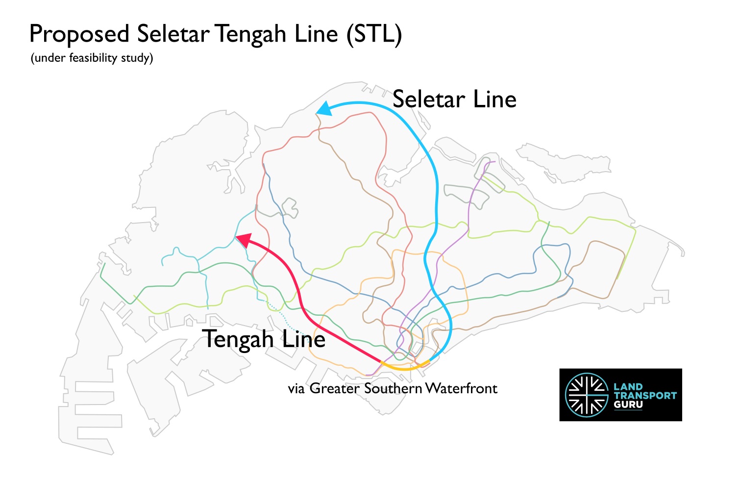
The Seletar Tengah Line (STL) is a proposed rail line in Singapore. Currently under feasibility studies, it combines previously announced proposals for two new rail lines in Singapore: the Seletar Line and the Tengah Line.
The name for the combined line was revealed in a recent Land Transport Authority (LTA) tender published on 4 May 2026, titled “Engineering Feasibility Study for the Proposed Seletar Tengah Line (STL)” (Contract S1006), possibly indicating that serious proposals are being explored to build them as a single line.
A Plan Years in the Making
The origins of the Seletar Line trace back to 2019, when the LTA unveiled its Land Transport Master Plan 2040 (LTMP 2040). That landmark document identified a need for better rail connectivity in the northern and north-eastern regions of Singapore — areas that, despite being home to large and growing populations, lacked direct access to the existing MRT network.
For several years, the proposed line remained a concept under study. Then, at the Committee of Supply (COS) Debate in March 2025, the LTA gave it a name: the Seletar Line. At the same debate, a second proposed line — the Tengah Line — was also announced, targeting the western corridor from Tengah through Bukit Batok and down towards Bukit Merah.
Crucially, the LTA also revealed that both lines could converge at the Greater Southern Waterfront, and that feasibility studies would explore whether they could be merged into a single unified line. This newly-launched Engineering Feasibility Study now refers to them as the Seletar Tengah Line (STL).
Catchment Areas
While the exact alignment of the line remains to be confirmed, the LTA has announced the potential catchment zones for each line as follows:
| Seletar Line | Tengah Line |
|
|
The Seletar Line serves developing and established towns in the north and northeast, benefiting more than 400,000 households and potentially cutting travel times to the city centre by up to 40 minutes for some commuters.
Likewise, Tengah is Singapore’s newest HDB town and will house 42,000 homes. A dedicated MRT line to the City would improve accessibility for its residents set to move in over the coming decade. The line’s reach through Bukit Batok and down to Bukit Merah and Queensway would also provide rail coverage in areas that currently rely heavily on buses.
Combining both lines?
If confirmed by the feasibility studies, a merged Seletar Tengah Line would form a transit corridor spanning from the north and north-east to the far west, anchored at the up-and-coming Greater Southern Waterfront precinct.
Apart from benefitting underserved estates along both northern and western corridors, the through-running line will allow commuters to travel directly between the northeast and the west without changing trains, reducing journey times and reducing congestion at interchange stations. The Greater Southern Waterfront is set to become a major residential, commercial and recreational district, and connecting it to the Seletar Tengah Line will offer excellent connectivity from day one.
Furthermore, Singapore is no stranger to combining planned MRT lines, with both the Downtown Line and the Thomson-East Coast Line products of similar mergers:
| Downtown Line | Thomson-East Coast Line |
| Bukit Timah Line + Eastern Region Line (north) + Circle Line (Downtown Extension) | Thomson Line + Eastern Region Line (south) |
| Merger announced 27 Apr 2007. Opened in three stages: 2013, 2015, 2017. | Merger announced 15 Aug 2014. Opened in stages from 2020 to 2026. |
The Downtown Line was conceived as three entirely separate projects: the Bukit Timah Line, intended to serve the northwestern Bukit Timah corridor; the northern half of the Eastern Region Line, a rectangular loop line that was originally planned to orbit the eastern side of the island; and the Downtown Extension, which began as a proposed branch of the Circle Line from Promenade to Chinatown serving the Marina Bay financial district. It was only in April 2007 that Transport Minister Raymond Lim announced all three would be consolidated into a single line built in three stages.
The Thomson-East Coast Line follows a similar story of convergence. The Thomson Line was first proposed in the Land Transport Master Plan 2008 as a standalone north–south corridor, complementing the North South Line and serving Woodlands, Upper Thomson and Bishan on its way to the city centre. Meanwhile, the Eastern Region Line‘s southern section had been planned to connect Marina Bay with the East Coast through Tanjong Rhu, Marine Parade and Bedok South. On 15 August 2014 — by which point construction of the Thomson Line had already begun — the LTA announced the two would be merged into a single through-running line. The result added nine new stations and extended the project from three to five stages.
Diagrams
Related Articles:
- Seletar Line | Land Transport Guru
- Tengah Line | Land Transport Guru
- COS 2025 Rail Expansion – Seletar, Tengah Lines & JRL West Coast Extension | Land Transport Guru
- Land Transport Master Plan 2040 – Key Public Transport Offerings | Land Transport Guru
Can LTA plan to connect the Seletar-Tengah Line with the Sengkang LRT Line at Fernvale Station to relieve congestion at Sengkang Station?
Please at least interchange with DTL east, need something to alleviate Macpherson…since CRL east doesn’t connect with DTL east…
Confirm will connect to DTL in the east, just not sure which DTL station will connect. I’ve seen many prediction on either Bendemeer (or Boon Keng-Bendemeer situated between the two station for long connection between NEL and DTL), Geylang Bahru or even Mattar so far.
If the lines get merged than most likely it’ll be the longest MRT line probably beating the EWL/CRL
If they merge (and they should): this could be the stations for the line in their phases:
Phase 1:
(ST1/TE1/RTS) Woodlands North
(ST2) Senoko
(ST3) Sembawang East
(ST4) Yishun East
(ST5) Seletar Airport
Phase 2:
(ST6/SW5) Fernvale
(ST7) Seletar Green
(ST8/CR9) Serangoon North
(ST9) Brighton
(ST10/CC14) Lorong Chuan
(ST11) Carmichael
(ST12/NE11) Woodleigh
(ST13) Joo Seng
(ST14/DT25) Mattar
(ST15/EW9) Aljunied
Phase 3:
(ST16) Guillemard
(ST17/CC7) Mountbatten
(ST18/TE24) Katong Park
(ST19) Marina East
(ST20) Marina Garden
(ST21/CC32) Prince Edward Road
Phase 4:
(ST22/NE2) Kampong Bahru (they should make NE2 a reality and interchange it with the STL)
(ST23) Mount Faber
(ST24) Bukit Merah
(ST25) Alexandra
(ST26) Ayer Rajah
(ST27/CC23) one-north
(ST28/EW22) Dover
Phase 5:
(ST29) Mount Sinai
(ST30/CR16) Maju
(ST31) Toh Tuck
(ST32) Bukit Batok East
(ST33/NS2) Bukit Batok
(ST34/JS3) Tengah
some minor changes: (ST3) Sembawang East name change to Montreal, (ST4) Yishun East name change to Nee Soon. New (ST34) Plantation between Bukit Batok and Tengah stations, hence Tengah’s new code will be (ST35/JS3)
To minimize land acquisition, a good part of the Tengah line alignment can use the former KTM alignment.