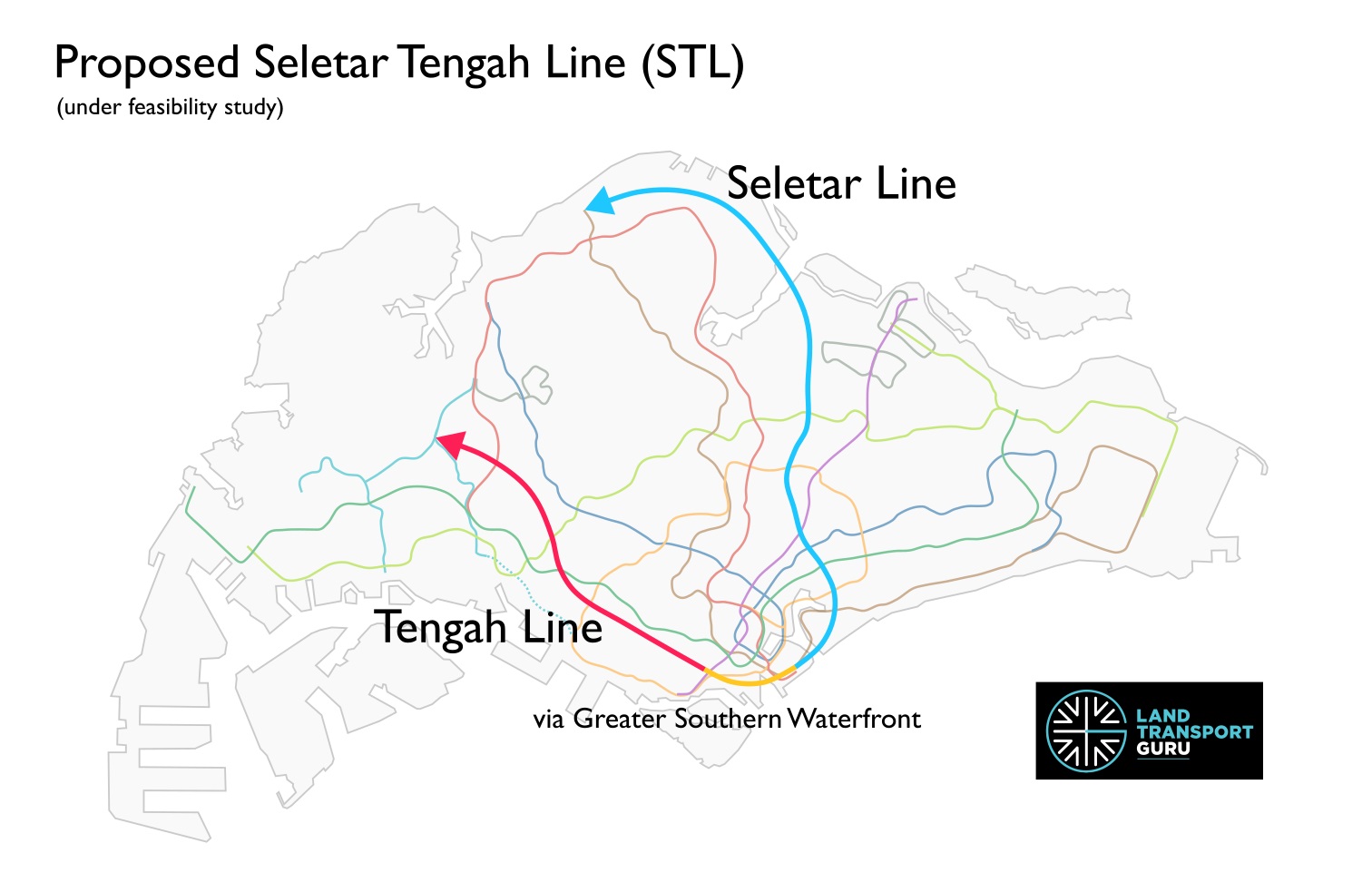
The Seletar Tengah Line (STL) is a proposed rail line in Singapore. Currently under feasibility studies, it combines previously announced proposals for two new rail lines in Singapore: the Seletar Line and the Tengah Line.
The name for the combined line was revealed in a recent Land Transport Authority (LTA) tender published on 4 May 2026, titled “Engineering Feasibility Study for the Proposed Seletar Tengah Line (STL)” (Contract S1006), possibly indicating that serious proposals are being explored to build them as a single line.
A Plan Years in the Making
The origins of the Seletar Line trace back to 2019, when the LTA unveiled its Land Transport Master Plan 2040 (LTMP 2040). That landmark document identified a need for better rail connectivity in the northern and north-eastern regions of Singapore — areas that, despite being home to large and growing populations, lacked direct access to the existing MRT network.
For several years, the proposed line remained a concept under study. Then, at the Committee of Supply (COS) Debate in March 2025, the LTA gave it a name: the Seletar Line. At the same debate, a second proposed line — the Tengah Line — was also announced, targeting the western corridor from Tengah through Bukit Batok and down towards Bukit Merah.
Crucially, the LTA also revealed that both lines could converge at the Greater Southern Waterfront, and that feasibility studies would explore whether they could be merged into a single unified line. This newly-launched Engineering Feasibility Study now refers to them as the Seletar Tengah Line (STL).
Catchment Areas
While the exact alignment of the line remains to be confirmed, the LTA has announced the potential catchment zones for each line as follows:
| Seletar Line | Tengah Line |
|
|
The Seletar Line serves developing and established towns in the north and northeast, benefiting more than 400,000 households and potentially cutting travel times to the city centre by up to 40 minutes for some commuters.
Likewise, Tengah is Singapore’s newest HDB town and will house 42,000 homes. A dedicated MRT line to the City would improve accessibility for its residents set to move in over the coming decade. The line’s reach through Bukit Batok and down to Bukit Merah and Queensway would also provide rail coverage in areas that currently rely heavily on buses.
Combining both lines?
If confirmed by the feasibility studies, a merged Seletar Tengah Line would form a transit corridor spanning from the north and north-east to the far west, anchored at the up-and-coming Greater Southern Waterfront precinct.
Apart from benefitting underserved estates along both northern and western corridors, the through-running line will allow commuters to travel directly between the northeast and the west without changing trains, reducing journey times and reducing congestion at interchange stations. The Greater Southern Waterfront is set to become a major residential, commercial and recreational district, and connecting it to the Seletar Tengah Line will offer excellent connectivity from day one.
Furthermore, Singapore is no stranger to combining planned MRT lines, with both the Downtown Line and the Thomson-East Coast Line products of similar mergers:
| Downtown Line | Thomson-East Coast Line |
| Bukit Timah Line + Eastern Region Line (north) + Circle Line (Downtown Extension) | Thomson Line + Eastern Region Line (south) |
| Merger announced 27 Apr 2007. Opened in three stages: 2013, 2015, 2017. | Merger announced 15 Aug 2014. Opened in stages from 2020 to 2026. |
The Downtown Line was conceived as three entirely separate projects: the Bukit Timah Line, intended to serve the northwestern Bukit Timah corridor; the northern half of the Eastern Region Line, a rectangular loop line that was originally planned to orbit the eastern side of the island; and the Downtown Extension, which began as a proposed branch of the Circle Line from Promenade to Chinatown serving the Marina Bay financial district. It was only in April 2007 that Transport Minister Raymond Lim announced all three would be consolidated into a single line built in three stages.
The Thomson-East Coast Line follows a similar story of convergence. The Thomson Line was first proposed in the Land Transport Master Plan 2008 as a standalone north–south corridor, complementing the North South Line and serving Woodlands, Upper Thomson and Bishan on its way to the city centre. Meanwhile, the Eastern Region Line‘s southern section had been planned to connect Marina Bay with the East Coast through Tanjong Rhu, Marine Parade and Bedok South. On 15 August 2014 — by which point construction of the Thomson Line had already begun — the LTA announced the two would be merged into a single through-running line. The result added nine new stations and extended the project from three to five stages.
Diagrams
Related Articles:
- Seletar Line | Land Transport Guru
- Tengah Line | Land Transport Guru
- COS 2025 Rail Expansion – Seletar, Tengah Lines & JRL West Coast Extension | Land Transport Guru
- Land Transport Master Plan 2040 – Key Public Transport Offerings | Land Transport Guru
By the way, I’m sure when we look at the map of STL, we would see that the STL has the potential of becoming a circle line. I have done some measurements on Google Maps (via drawing lines), and determine the current STL to be approximately 48km, and the potential “close the circle” route via Lim Chu Kang to be approximately 20km.
If the intention is to eventually make STL into a circle line, while using the standard MRT train (maximum operating speed 80km/h), and ensuring that the total travel time to complete one loop (68km) is 60 minutes (so that it is comparable to the EWL and the CCL), I have calculated via chat gpt and determined that the eventual circle line STL can only have a total of 12 to 15 stations (or, around 13.5 stations).
Which means the current STL should only have (48/68)x13.5 = 9.529stations, and the potential close the loop via Lim Chu Kang should only have (20/68)x13.5 = 3.971stations, if the intention is for STL to eventually become a circle line.
Therefore, the STL stations should be spaced about 68/13.5 = 5.037km apart.
I have measured on Google Maps and identified the following 10 stations that can be on the current STL, that are about 5 km apart from each other, and can be connected via main roads:
> Tengah > Beauty World > Kent Ridge > Bukit Purmei > Marina South > Mattar > Serangoon North > Seletar Airport > Canberra Way > Woodlands North >
Whereas for the potential close the loop via Lim Chu Kang, I have identified 3 suitable stations that are about 5km apart (the connecting part back to Tengah only about 2km).
> Sungei Kadut > Sungei Gedong > Jalan Bahar mountain area >
Total = 13 stations only, enabling this potential STL circle line to complete the approximately 68km loop in 60 minutes, using a standard MRT train that has maximum speed of 80km/h.
Having stations 5km apart is probably currently only found at NSL YCK to Khatib. Yet, this kind of station distance is common in cross country railway lines at Taiwan and Australia. So, perhaps Singapore may want to take STL as the chance (and probably the only chance) to have a railway line with stations that are 5km apart. It can potentially be Singapore’s only chance to have an express train line.
So really, whatever I have written above, about STL potentially becoming a circle line eventually, can really be considered. It can even help to achieve time-space revolution with the 5km station distance that is required to ensure that the eventual loop of the STL can be completed within 60 minutes while using the standard MRT train and system.
And to minimize costs, they should consider making the STL run elevated or ground level wherever possible – just like the cross country railway lines at Taiwan and Australia which usually run at ground level.
Should’ve used the unused platform provisions at Esplanade, then it’s better this way.
The merger is confirmed huh
Time for station predictions:
Woodlands North is obvious, following that a station in Senoko (making sure to skirt away from the micron fab to prevent disruptions)
Sembawang North may get two stations, taking into account the new trend of MRT lines having stations close to each other, and in preparation for the relocation of Sembawang Shipyard & the new residential town to be built there.
Canberra East and two stations in Yishun East are possible. Though the line would have to skirt another micron fab in Yishun Industrial. Hopefully these two stations are enough to serve Simpang New Town as well, if it ever comes to fruition
I’m doubtful whether a station can be put at Seletar Airport. It would involve tunnelling directly under the airspace & runway, which probably means LDTBMs need to be used (same way CRL is tunnelled under the CCNR). The airport is a restricted zone after all, just like Changi. So Seletar Airport Station would have to be quite deep underground.
Certain rumours have mentioned station sites at Piccadilly & Jalan Kayu. Fernvale is still a question mark. These same rumours allege that there is no interchange station with SKLRT at Fernvale, rather the station is placed at the junction of YCK Road & SK West Rd.
^ the alignment makes sense, since it is already confirmed to interchange with the CRL at Tavistock. But station placement is ???
Interchanging with CCL at Lor Chuan, one or two stations in TPY East, one station in Whampoa should be easy guesses. NEL at Boon Keng should be good. However I personally don’t think there will be any interchange with the DTL. Bendemeer is too far out of reach to interchange with (either your transfer distance is long, or the line curves and twists too much, cue TEL).
EWL at Kallang, CCL at Mountbatten (there is just more space here, Stadium doesn’t look like a good choice), TEL at Katong Park? (with the immense space constraints here its gonna be difficult. TEL already had to be squeezed into stacked platforms to fit)
One station in Marina East, to serve future developments here. And finally, NSL at Marina South Pier
Bearing in mind the new cruise centre that was just announced yesterday, a station could be placed right there, alongside two other stations in GSW New Town. Interchanging with CCL at Keppel (which is kind of confirmed already), it could go on having stations at Bukit Merah & Alexandra. EWL at Commonwealth is more or less confirmed as well, following that CCL at Holland Village. One station could be placed at Jelita before meeting the CRL at Maju, serving new residential developments there
After this, let’s assume the line follows the alignment of the Roblox MRT game Holland-Long Island Line: Burgundy, Bukit Batok, Bukit Batok West & Tengah, which makes perfect sense
Biggest question here: how will they open this, and more importantly WHEN. With the population of both the West & the North East booming quickly, by the time they finish their “engineering studies” for this line it has gone past 5 years, while construction would likely take another 10 years (TOO SLOW). 2040+ is not a good deadline, because by then the EWL & NEL will have gone overcapacity, while JRL will begin struggling, being the sole rail line in the entire Tengah Town.
And what phases will they open this? Will they open the Woodlands-Sengkang side first? Or the Tengah – Holland side first? Will they open both at the same time? (which would have been easier if they STAYED SEPARATE). What if they open the CBD section first, just like DTL did. Mega dilemma here.
At least can they not make the same mistake again like the Circle Line and close the loop at the Northwest portion.
Wonder if Yishun is included..
Doubt it considering the northern part of the STL would probably be running parallel to the NSL not interchange with it…at least not by much(most likely not at all)